| Introduction - Niger: |
| Country | Niger |
|
|
|
| Background | Niger became independent from France in 1960 and experienced single-party and military rule until 1991, when Gen. Ali SAIBOU was forced by public pressure to allow multiparty elections, which resulted in a democratic government in 1993. Political infighting brought the government to a standstill and in 1996 led to a coup by Col. Ibrahim BARE. In 1999 BARE was killed in a coup by military officers who promptly restored democratic rule and held elections that brought Mamadou TANDJA to power in December of that year. TANDJA was reelected in 2004. Niger is one of the poorest countries in the world with minimal government services and insufficient funds to develop its resource base. The largely agrarian and subsistence-based economy is frequently disrupted by extended droughts common to the Sahel region of Africa. |
|
|
|
| Location - Niger: |
| Location | Western Africa, southeast of Algeria |
|
| Geographic coordinates | 16 00 N, 8 00 E |
|
| Map references | Africa |
|
| Area | total: 1.267 million sq km
land: 1,266,700 sq km
water: 300 sq km |
|
| Area comparative | slightly less than twice the size of Texas |
|
| Land boundaries | total: 5,697 km
border countries: Algeria 956 km, Benin 266 km, Burkina Faso 628 km, Chad 1,175 km, Libya 354 km, Mali 821 km, Nigeria 1,497 km |
|
| Coastline | 0 km (landlocked) |
|
| Maritime claims | none (landlocked) |
|
| Climate | desert; mostly hot, dry, dusty; tropical in extreme south |
|
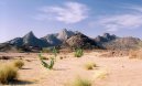
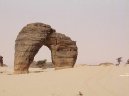
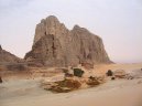
| Terrain | predominately desert plains and sand dunes; flat to rolling plains in south; hills in north |
|
| Elevation extremes | lowest point: Niger River 200 m
highest point: Mont Bagzane 2,022 m |
|
| Natural resources | uranium, coal, iron ore, tin, phosphates, gold, molybdenum, gypsum, salt, petroleum |
|
| Land use | arable land: 11.43%
permanent crops: 0.01%
other: 88.56% (2005) |
|
| Irrigated land | 730 sq km (2003) |
|
| Natural hazards | recurring droughts |
|
| Environment current issues | overgrazing; soil erosion; deforestation; desertification; wildlife populations (such as elephant, hippopotamus, giraffe, and lion) threatened because of poaching and habitat destruction |
|
| Environment international agreements | party to: Biodiversity, Climate Change, Climate Change-Kyoto Protocol, Desertification, Endangered Species, Environmental Modification, Hazardous Wastes, Ozone Layer Protection, Wetlands
signed, but not ratified: Law of the Sea |
|
| Geography note | landlocked; one of the hottest countries in the world; northern four-fifths is desert, southern one-fifth is savanna, suitable for livestock and limited agriculture |
|
| People - Niger: |
| Population | 12,894,865 (July 2007 est.) |
|
| Age structure | 0-14 years: 46.9% (male 3,083,871/female 2,969,201)
15-64 years: 50.6% (male 3,354,783/female 3,174,039)
65 years and over: 2.4% (male 155,430/female 157,541) (2007 est.) |
|
| Median age | total: 16.5 years
male: 16.5 years
female: 16.4 years (2007 est.) |
|
| Population growth rate | 2.898% (2007 est.) |
|
| Birth rate | 50.16 births/1,000 population (2007 est.) |
|
| Death rate | 20.59 deaths/1,000 population (2007 est.) |
|
| Net migration rate | -0.59 migrant(s)/1,000 population (2007 est.) |
|
| Sex ratio | at birth: 1.03 male(s)/female
under 15 years: 1.039 male(s)/female
15-64 years: 1.057 male(s)/female
65 years and over: 0.987 male(s)/female
total population: 1.047 male(s)/female (2007 est.) |
|
| Infant mortality rate | total: 116.83 deaths/1,000 live births
male: 120.78 deaths/1,000 live births
female: 112.76 deaths/1,000 live births (2007 est.) |
|
| Life expectancy at birth | total population: 44.03 years
male: 44.05 years
female: 44 years (2007 est.) |
|
| Total fertility rate | 7.37 children born/woman (2007 est.) |
|
| Hiv aids adult prevalence rate | 1.2% (2003 est.) |
|
| Hiv aids people living with hiv aids | 70,000 (2003 est.) |
|
| Hiv aids deaths | 4,800 (2003 est.) |
|
| Nationality | noun: Nigerien(s)
adjective: Nigerien |
|
| Major infectious diseases | degree of risk: very high
food or waterborne diseases: bacterial and protozoal diarrhea, hepatitis A, and typhoid fever
vectorborne disease: malaria is a high risk in some locations
respiratory disease: meningococcal meningitis
note: highly pathogenic H5N1 avian influenza has been identified among birds in this country or surrounding region; it poses a negligible risk with extremely rare cases possible among US citizens who have close contact with birds (2007) |
|
| Ethnic groups | Haoussa 55.4%, Djerma Sonrai 21%, Touareg 9.3%, Peuhl 8.5%, Kanouri Manga 4.7%, other 1.2% (2001 census) |
|
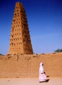
| Religions | Muslim 80%, other (includes indigenous beliefs and Christian) 20% |
|
| Languages | French (official), Hausa, Djerma |
|
| Literacy | definition: age 15 and over can read and write
total population: 28.7%
male: 42.9%
female: 15.1% (2005 est.) |
|
| Government - Niger: |
| Country name | conventional long form: Republic of Niger
conventional short form: Niger
local long form: Republique du Niger
local short form: Niger |
|
| Government type | republic |
|
| Capital | name: Niamey
geographic coordinates: 13 31 N, 2 07 E
time difference: UTC+1 (6 hours ahead of Washington, DC during Standard Time) |
|
| Administrative divisions | 8 regions (regions, singular - region) includes 1 capital district* (communite urbaine); Agadez, Diffa, Dosso, Maradi, Niamey*, Tahoua, Tillaberi, Zinder |
|
| Independence | 3 August 1960 (from France) |
|
| National holiday | Republic Day, 18 December (1958) |
|
| Constitution | new constitution adopted 18 July 1999 |
|
| Legal system | based on French civil law system and customary law; has not accepted compulsory ICJ jurisdiction |
|
| Suffrage | 18 years of age; universal |
|
| Executive branch | chief of state: President Mamadou TANDJA (since 22 December 1999); note - the president is both chief of state and head of government
head of government: President Mamadou TANDJA (since 22 December 1999); Prime Minister Seyni OUMAROU (since 3 June 2007) was appointed by the president and shares some executive responsibilities with the president
cabinet: 26-member Cabinet appointed by the president
elections: president elected by popular vote for a five-year term (eligible for a second term); second round of election last held 4 December 2004 (next to be held December 2009)
election results: Mamadou TANDJA reelected president; percent of vote - Mamadou TANDJA 65.5%, Mahamadou ISSOUFOU 34.5% |
|
| Legislative branch | unicameral National Assembly (113 seats; members elected by popular vote to serve five-year terms)
elections: last held 4 December 2004 (next to be held in December 2009)
election results: percent of vote by party - NA; seats by party - MNSD 47, PNDS 25, CDS 22, RSD 7, RDP 6, ANDP 5, PSDN 1 |
|
| Judicial branch | State Court or Cour dEtat; Court of Appeals or Cour dAppel |
|
| Political parties and leaders | Democratic and Social Convention-Rahama or CDS-Rahama [Mahamane OUSMANE]; National Movement for a Developing Society-Nassara or MNSD-Nassara [Hama AMADOU]; Niger Social Democratic Party or PSDN; Nigerien Alliance for Democracy and Social Progress-Zaman Lahiya or ANDP-Zaman Lahiya [Moumouni DJERMAKOYE]; Nigerien Party for Autonomy or PNA-Aloumaa [Sanousi JACKOU]; Nigerien Party for Democracy and Socialism or PNDS-Tarrayya [Issifou MAHAMADOU]; Nigerien Progressive Party or PPN-RDA [Abdoulaye DIORI]; Rally for Democracy and Progress or RDP-jamaa [Hamid ALGABID]; Social and Democratic Rally or RSD-Gaskiyya [Cheiffou AMADOU] |
|
| Political pressure groups and leaders | Coalition Against a High Cost of Living [Nouhou ARZIKA] |
|
| International organization participation | ACCT, ACP, AfDB, AU, ECOWAS, Entente, FAO, FZ, G-77, IAEA, IBRD, ICAO, ICCt, ICRM, IDA, IDB, IFAD, IFC, IFRCS, ILO, IMF, Interpol, IOC, IOM, IPU, ISO (correspondent), ITSO, ITU, ITUC, MONUC, NAM, OIC, OIF, ONUB, OPCW, UN, UNCTAD, UNESCO, UNIDO, UNMIL, UNOCI, UNWTO, UPU, WADB (regional), WAEMU, WCL, WCO, WFTU, WHO, WIPO, WMO, WTO |
|
| Diplomatic representation in the us | chief of mission: Ambassador Aminata Maiga Djibrilla TOURE
chancery: 2204 R Street NW, Washington, DC 20008
telephone: [1] (202) 483-4224 through 4227
FAX: [1] (202)483-3169 |
|
| Diplomatic representation from the us | chief of mission: Ambassador Bernadette M. ALLEN
embassy: Rue Des Ambassades, Niamey
mailing address: B. P. 11201, Niamey
telephone: [227] 73 31 69
FAX: [227] 73 55 60 |
|
| Flag description | three equal horizontal bands of orange (top), white, and green with a small orange disk (representing the sun) centered in the white band; similar to the flag of India, which has a blue spoked wheel centered in the white band |
|
| Economy - Niger: |
| Economy overview | Niger is one of the poorest countries in the world, ranking last on the United Nations Development Fund index of human development. It is a landlocked, Sub-Saharan nation, whose economy centers on subsistence crops, livestock, and some of the worlds largest uranium deposits. Drought cycles, desertification, and a 2.9% population growth rate, have undercut the economy. Niger shares a common currency, the CFA franc, and a common central bank, the Central Bank of West African States (BCEAO), with seven other members of the West African Monetary Union. In December 2000, Niger qualified for enhanced debt relief under the International Monetary Fund program for Highly Indebted Poor Countries (HIPC) and concluded an agreement with the Fund on a Poverty Reduction and Growth Facility (PRGF). Debt relief provided under the enhanced HIPC initiative significantly reduces Nigers annual debt service obligations, freeing funds for expenditures on basic health care, primary education, HIV/AIDS prevention, rural infrastructure, and other programs geared at poverty reduction. In December 2005, Niger received 100% multilateral debt relief from the IMF, which translates into the forgiveness of approximately US $86 million in debts to the IMF, excluding the remaining assistance under HIPC. Nearly half of the governments budget is derived from foreign donor resources. Future growth may be sustained by exploitation of oil, gold, coal, and other mineral resources. Uranium prices have increased sharply in the last few years. A drought and locust infestation in 2005 led to food shortages for as many as 2.5 million Nigeriens. |
|
| Gdp purchasing power parity | $12.36 billion (2006 est.) |
|
| Gdp official exchange rate | $3.638 billion (2006 est.) |
|
| Gdp real growth rate | 3.5% (2006 est.) |
|
| Gdp per capita ppp | $1,000 (2006 est.) |
|
| Gdp composition by sector | agriculture: 39%
industry: 17%
services: 44% (2001) |
|
| Labor force | 70,000 salaried workers, 60% of whom are employed in the public sector (2002 est.) |
|
| Labor force by occupation | agriculture: 90%
industry: 6%
services: 4% |
|
| Unemployment rate | NA% |
|
| Population below poverty line | 63% (1993 est.) |
|
| Household income or consumption by percentage share | lowest 10%: 0.8%
highest 10%: 35.4% (1995) |
|
| Distribution of family income gini index | 50.5 (1995) |
|
| Inflation rate consumer prices | 0.2% (2004 est.) |
|
| Budget | revenues: $320 million (includes $134 million from foreign sources)
expenditures: $320 million; including capital expenditures of $178 million (2002 est.) |
|
| Agriculture products | cowpeas, cotton, peanuts, millet, sorghum, cassava (tapioca), rice; cattle, sheep, goats, camels, donkeys, horses, poultry |
|
| Industries | uranium mining, cement, brick, soap, textiles, food processing, chemicals, slaughterhouses |
|
| Industrial production growth rate | 5.1% (2003 est.) |
|
| Electricity production | 232 million kWh (2004) |
|
| Electricity consumption | 415.8 million kWh (2004) |
|
| Electricity exports | 0 kWh (2004) |
|
| Electricity imports | 200 million kWh (2004) |
|
| Oil production | 0 bbl/day (2004 est.) |
|
| Oil consumption | 5,500 bbl/day (2004 est.) |
|
| Oil exports | NA bbl/day |
|
| Oil imports | NA bbl/day |
|
| Oil proved reserves | 0 bbl |
|
| Natural gas production | 0 cu m (2004 est.) |
|
| Natural gas consumption | 0 cu m (2004 est.) |
|
| Exports | $222 million f.o.b. (2004 est.) |
|
| Exports commodities | uranium ore, livestock, cowpeas, onions |
|
| Exports partners | France 34.8%, US 26.5%, Nigeria 18.3%, Russia 11.3% (2006) |
|
| Imports | $588 million f.o.b. (2004 est.) |
|
| Imports commodities | foodstuffs, machinery, vehicles and parts, petroleum, cereals |
|
| Imports partners | US 14.2%, France 12.2%, China 7.9%, Nigeria 7.8%, French Polynesia 7.8%, Cote dIvoire 5% (2006) |
|
| Debt external | $2.1 billion (2003 est.) |
|
| Economic aid recipient | $453.3 million (2003) |
|
| Currency code | Communaute Financiere Africaine franc (XOF); note - responsible authority is the Central Bank of the West African States (BCEAO) |
|
| Exchange rates | Communaute Financiere Africaine francs (XOF) per US dollar - 522.59 (2006), 527.47 (2005), 528.29 (2004), 581.2 (2003), 696.99 (2002) |
|
| Communications - Niger: |
| Fiscal year | calendar year |
|
| Telephones main lines in use | 24,000 (2005) |
|
| Telephones mobile cellular | 323,900 (2005) |
|
| Telephone system | general assessment: small system of wire, radio telephone communications, and microwave radio relay links concentrated in the southwestern area of Niger
domestic: wire, radiotelephone communications, and microwave radio relay; domestic satellite system with 3 earth stations and 1 planned
international: country code - 227; satellite earth stations - 2 Intelsat (1 Atlantic Ocean and 1 Indian Ocean) |
|
| Radio broadcast stations | AM 5, FM 6, shortwave 4 (2001) |
|
| Television broadcast stations | 3 (plus 7 repeaters) (2002) |
|
| Internet country code | .ne |
|
| Internet hosts | 189 (2006) |
|
| Internet users | 40,000 (2006) |
|
| Transportation - Niger: |
| Airports | 28 (2006) |
|
| Airports with paved runways | total: 9
2,438 to 3,047 m: 3
1,524 to 2,437 m: 5
under 914 m: 1 (2006) |
|
| Airports with unpaved runways | total: 19
1,524 to 2,437 m: 2
914 to 1,523 m: 15
under 914 m: 2 (2006) |
|
| Roadways | total: 14,565 km
paved: 3,641 km
unpaved: 10,924 km (2004) |
|
| Waterways | 300 km (the Niger, the only major river, is navigable to Gaya between September and March) (2005) |
|
| Ports and terminals | none |
|
| Military - Niger: |
| Military branches | Nigerien Armed Forces (Forces Armees Nigeriennes, FAN): Army, Niger Air Force (2007) |
|
| Military service age and obligation | 18 years of age for compulsory military service; 2-year conscript service obligation (2006) |
|
| Manpower available for military service | males age 18-49: 2,367,828
females age 18-49: 2,217,568 (2005 est.) |
|
| Manpower fit for military service | males age 18-49: 1,349,863
females age 18-49: 1,256,569 (2005 est.) |
|
| Manpower reaching military service age annually | males age 18-49: 129,045
females age 18-49: 121,230 (2005 est.) |
|
| Military expenditures percent of gdp | 1.3% (2006) |
|
This page was last updated on 16 September, 2007