| Introduction - Mali: |
| Country | Mali |
|
|
|
| Background | The Sudanese Republic and Senegal became independent of France in 1960 as the Mali Federation. When Senegal withdrew after only a few months, what formerly made up the Sudanese Republic was renamed Mali. Rule by dictatorship was brought to a close in 1991 by a coup that ushered in democratic government. President Alpha KONARE won Malis first democratic presidential election in 1992 and was reelected in 1997. In keeping with Malis two-term constitutional limit, KONARE stepped down in 2002 and was succeeded by Amadou TOURE. |
|
|
|
| Location - Mali: |
| Location | Western Africa, southwest of Algeria |
|
| Geographic coordinates | 17 00 N, 4 00 W |
|
| Map references | Africa |
|
| Area | total: 1.24 million sq km
land: 1.22 million sq km
water: 20,000 sq km |
|
| Area comparative | slightly less than twice the size of Texas |
|
| Land boundaries | total: 7,243 km
border countries: Algeria 1,376 km, Burkina Faso 1,000 km, Guinea 858 km, Cote dIvoire 532 km, Mauritania 2,237 km, Niger 821 km, Senegal 419 km |
|
| Coastline | 0 km (landlocked) |
|
| Maritime claims | none (landlocked) |
|
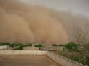
| Climate | subtropical to arid; hot and dry (February to June); rainy, humid, and mild (June to November); cool and dry (November to February) |
|
| Terrain | mostly flat to rolling northern plains covered by sand; savanna in south, rugged hills in northeast |
|
| Elevation extremes | lowest point: Senegal River 23 m
highest point: Hombori Tondo 1,155 m |
|
| Natural resources | gold, phosphates, kaolin, salt, limestone, uranium, gypsum, granite, hydropower
note: bauxite, iron ore, manganese, tin, and copper deposits are known but not exploited |
|
| Land use | arable land: 3.76%
permanent crops: 0.03%
other: 96.21% (2005) |
|
| Irrigated land | 2,360 sq km (2003) |
|
| Natural hazards | hot, dust-laden harmattan haze common during dry seasons; recurring droughts; occasional Niger River flooding |
|
| Environment current issues | deforestation; soil erosion; desertification; inadequate supplies of potable water; poaching |
|
| Environment international agreements | party to: Biodiversity, Climate Change, Climate Change-Kyoto Protocol, Desertification, Endangered Species, Hazardous Wastes, Law of the Sea, Ozone Layer Protection, Wetlands, Whaling
signed, but not ratified: none of the selected agreements |
|
| Geography note | landlocked; divided into three natural zones: the southern, cultivated Sudanese; the central, semiarid Sahelian; and the northern, arid Saharan |
|
| People - Mali: |
| Population | 11,995,402 (July 2007 est.) |
|
| Age structure | 0-14 years: 48.2% (male 2,921,914/female 2,853,976)
15-64 years: 48.8% (male 2,891,494/female 2,959,142)
65 years and over: 3.1% (male 149,301/female 219,575) (2007 est.) |
|
| Median age | total: 15.9 years
male: 15.4 years
female: 16.3 years (2007 est.) |
|
| Population growth rate | 2.681% (2007 est.) |
|
| Birth rate | 49.61 births/1,000 population (2007 est.) |
|
| Death rate | 16.51 deaths/1,000 population (2007 est.) |
|
| Net migration rate | -6.28 migrant(s)/1,000 population (2007 est.) |
|
| Sex ratio | at birth: 1.03 male(s)/female
under 15 years: 1.024 male(s)/female
15-64 years: 0.977 male(s)/female
65 years and over: 0.68 male(s)/female
total population: 0.988 male(s)/female (2007 est.) |
|
| Infant mortality rate | total: 105.65 deaths/1,000 live births
male: 115.29 deaths/1,000 live births
female: 95.72 deaths/1,000 live births (2007 est.) |
|
| Life expectancy at birth | total population: 49.51 years
male: 47.6 years
female: 51.46 years (2007 est.) |
|
| Total fertility rate | 7.38 children born/woman (2007 est.) |
|
| Hiv aids adult prevalence rate | 1.9% (2003 est.) |
|
| Hiv aids people living with hiv aids | 140,000 (2003 est.) |
|
| Hiv aids deaths | 12,000 (2003 est.) |
|
| Nationality | noun: Malian(s)
adjective: Malian |
|
| Major infectious diseases | degree of risk: very high
food or waterborne diseases: bacterial and protozoal diarrhea, hepatitis A, and typhoid fever
vectorborne disease: malaria is a high risk in some locations
water contact disease: schistosomiasis
respiratory disease: meningococcal meningitis (2007) |
|
| Ethnic groups | Mande 50% (Bambara, Malinke, Soninke), Peul 17%, Voltaic 12%, Songhai 6%, Tuareg and Moor 10%, other 5% |
|
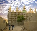
| Religions | Muslim 90%, Christian 1%, indigenous beliefs 9% |
|
| Languages | French (official), Bambara 80%, numerous African languages |
|
| Literacy | definition: age 15 and over can read and write
total population: 46.4%
male: 53.5%
female: 39.6% (2003 est.) |
|
| Government - Mali: |
| Country name | conventional long form: Republic of Mali
conventional short form: Mali
local long form: Republique de Mali
local short form: Mali
former: French Sudan and Sudanese Republic |
|
| Government type | republic |
|
| Capital | name: Bamako
geographic coordinates: 12 39 N, 8 00 W
time difference: UTC 0 (5 hours ahead of Washington, DC during Standard Time) |
|
| Administrative divisions | 8 regions (regions, singular - region); Gao, Kayes, Kidal, Koulikoro, Mopti, Segou, Sikasso, Tombouctou |
|
| Independence | 22 September 1960 (from France) |
|
| National holiday | Independence Day, 22 September (1960) |
|
| Constitution | adopted 12 January 1992 |
|
| Legal system | based on French civil law system and customary law; judicial review of legislative acts in Constitutional Court; has not accepted compulsory ICJ jurisdiction |
|
| Suffrage | 18 years of age; universal |
|
| Executive branch | chief of state: President Amadou Toumani TOURE (since 8 June 2002)
head of government: Prime Minister Ousmane Issoufi MAIGA (since 30 April 2004)
cabinet: Council of Ministers appointed by the prime minister
elections: president elected by popular vote for a five-year term (eligible for a second term); election last held 29 April 2007 (next to be held April in 2012); prime minister appointed by the president
election results: Amadou Toumani TOURE reelected president; percent of vote - Amadou Toumani TOURE 71.2%, Ibrahim Boubacar KEITA 19.2%, other 9.6% |
|
| Legislative branch | unicameral National Assembly or Assemblee Nationale (147 seats; members elected by popular vote to serve five-year terms)
elections: last held 1 and 22 July 2007 (next to be held in July 2012)
election results: percent of vote by party - NA; seats by party - ADP coalition 113 (including ADEMA 51, URD 34, MPR 8, CNID 7, UDD 3, and other 10), FDR coalition 15 (including RPM 11, PARENA 4), SADI 4, independent 15 |
|
| Judicial branch | Supreme Court or Cour Supreme |
|
| Political parties and leaders | African Solidarity for Democracy and Independence or SADI [Oumar MARIKO, secretary general]; Alliance for Democracy and Progress or ADP (a coalition of political parties including ADEMA and URD formed in December 2006 to support the presidential candidacy of Amadou TOURE); Alliance for Democracy or ADEMA [Diounconda TRAORE]; Convergence 2007 [Soumeylou Boubeye MAIGA]; Front for Democracy and the Republic or FDR (a coalition of political parties including RPM and PARENA formed to oppose the presidential candidacy of Amadou TOURE); National Congress for Democratic Initiative or CNID [Mountaga TALL]; Party for Democracy and Progress or PDP [Me Idrissa TRAORE]; Party for National Renewal or PARENA [Tiebile DRAME]; Patriotic Movement for Renewal or MPR [Choguel MAIGA]; Rally for Democracy and Labor or RDT; Rally for Mali or RPM [Ibrahim Boubacar KEITA]; Sudanese Union/African Democratic Rally or US/RDA [Mamadou Bamou TOURE]; Union for Democracy and Development or UDD [Moussa Balla COULIBALY]; Union for Republic and Democracy or URD [Soumaila CISSE] |
|
| Political pressure groups and leaders | Alliance for Democratic Change or ACD; Patriotic Movement of the Ghanda Koye or MPGK; United Movement and Fronts of Azawad or MFUA |
|
| International organization participation | ACCT, ACP, AfDB, AU, ECOWAS, FAO, FZ, G-77, IAEA, IBRD, ICAO, ICCt, ICRM, IDA, IDB, IFAD, IFC, IFRCS, ILO, IMF, Interpol, IOC, IOM, IPU, ISO (correspondent), ITSO, ITU, ITUC, MIGA, MONUC, NAM, OIC, OIF, ONUB, OPCW, UN, UNCTAD, UNESCO, UNIDO, UNMIL, UNMIS, UNWTO, UPU, WADB (regional), WAEMU, WCO, WFTU, WHO, WIPO, WMO, WTO |
|
| Diplomatic representation in the us | chief of mission: Ambassador Abdoulaye DIOP
chancery: 2130 R Street NW, Washington, DC 20008
telephone: [1] (202) 332-2249, 939-8950
FAX: [1] (202) 332-6603 |
|
| Diplomatic representation from the us | chief of mission: Ambassador Terrence P. MCCULLEY
embassy: Rue Rochester NY and Rue Mohamed V, Bamako
mailing address: B. P. 34, Bamako
telephone: [223] 222-5470
FAX: [223] 222-3712 |
|
| Flag description | three equal vertical bands of green (hoist side), yellow, and red; uses the popular pan-African colors of Ethiopia |
|
| Economy - Mali: |
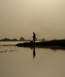
| Economy overview | Mali is among the poorest countries in the world, with 65% of its land area desert or semidesert and with a highly unequal distribution of income. Economic activity is largely confined to the riverine area irrigated by the Niger. About 10% of the population is nomadic and some 80% of the labor force is engaged in farming and fishing. Industrial activity is concentrated on processing farm commodities. Mali is heavily dependent on foreign aid and vulnerable to fluctuations in world prices for cotton, its main export, along with gold. The government has continued its successful implementation of an IMF-recommended structural adjustment program that is helping the economy grow, diversify, and attract foreign investment. Malis adherence to economic reform and the 50% devaluation of the CFA franc in January 1994 have pushed up economic growth to a sturdy 5% average in 1996-2006. Worker remittances and external trade routes for the landlocked country have been jeopardized by continued unrest in neighboring Cote dIvoire. |
|
| Gdp purchasing power parity | $14.77 billion (2006 est.) |
|
| Gdp official exchange rate | $5.847 billion (2006 est.) |
|
| Gdp real growth rate | 5.1% (2006 est.) |
|
| Gdp per capita ppp | $1,300 (2006 est.) |
|
| Gdp composition by sector | agriculture: 45%
industry: 17%
services: 38% (2001 est.) |
|
| Labor force | 3.93 million (2001 est.) |
|
| Labor force by occupation | agriculture: 80%
industry and services: 20% (2001 est.) |
|
| Unemployment rate | 14.6% (2001 est.) |
|
| Population below poverty line | 64% (2001 est.) |
|
| Household income or consumption by percentage share | lowest 10%: 1.8%
highest 10%: 40.4% (1994) |
|
| Distribution of family income gini index | 50.5 (1994) |
|
| Inflation rate consumer prices | 4.5% (2002 est.) |
|
| Budget | revenues: $764 million
expenditures: $828 million; including capital expenditures of $NA (2002 est.) |
|
| Agriculture products | cotton, millet, rice, corn, vegetables, peanuts; cattle, sheep, goats |
|
| Industries | food processing; construction; phosphate and gold mining |
|
| Industrial production growth rate | NA% |
|
| Electricity production | 410 million kWh (2004) |
|
| Electricity consumption | 381.3 million kWh (2004) |
|
| Electricity exports | 0 kWh; note - recent hydropower developments may be providing electricity to Senegal and Mauritania (2004) |
|
| Electricity imports | 0 kWh (2004) |
|
| Oil production | 0 bbl/day (2004 est.) |
|
| Oil consumption | 4,300 bbl/day (2004 est.) |
|
| Oil exports | NA bbl/day |
|
| Oil imports | NA bbl/day |
|
| Oil proved reserves | 0 bbl |
|
| Natural gas production | 0 cu m (2004 est.) |
|
| Natural gas consumption | 0 cu m (2004 est.) |
|
| Exports | $323 million f.o.b. (2004 est.) |
|
| Exports commodities | cotton, gold, livestock |
|
| Exports partners | China 35.6%, Thailand 9.4%, Taiwan 8.1%, Bangladesh 5.3%, Australia 5% (2006) |
|
| Imports | $1.858 billion f.o.b. (2004 est.) |
|
| Imports commodities | petroleum, machinery and equipment, construction materials, foodstuffs, textiles |
|
| Imports partners | Senegal 13.8%, France 12.6%, Cote dIvoire 10.2% (2006) |
|
| Debt external | $2.8 billion (2002) |
|
| Economic aid recipient | $472.1 million (2002) |
|
| Currency code | Communaute Financiere Africaine franc (XOF); note - responsible authority is the Central Bank of the West African States |
|
| Exchange rates | Communaute Financiere Africaine francs (XOF) per US dollar - 522.59 (2006), 527.47 (2005), 528.29 (2004), 581.2 (2003), 696.99 (2002) |
|
| Communications - Mali: |
| Fiscal year | calendar year |
|
| Telephones main lines in use | 75,000 (2005) |
|
| Telephones mobile cellular | 869,600 (2005) |
|
| Telephone system | general assessment: domestic system unreliable but improving; provides only minimal service
domestic: network consists of microwave radio relay, open-wire, and radiotelephone communications stations; expansion of microwave radio relay in progress
international: country code - 223; satellite earth stations - 2 Intelsat (1 Atlantic Ocean, 1 Indian Ocean) |
|
| Radio broadcast stations | AM 1, FM 28, shortwave 1 (the shortwave station in Bamako has seven frequencies and five transmitters and relays broadcasts for China Radio International) (2001) |
|
| Television broadcast stations | 1 (plus repeaters) (2001) |
|
| Internet country code | .ml |
|
| Internet hosts | 278 (2006) |
|
| Internet users | 70,000 (2006) |
|
| Transportation - Mali: |
| Airports | 29 (2006) |
|
| Airports with paved runways | total: 9
2,438 to 3,047 m: 4
1,524 to 2,437 m: 4
914 to 1,523 m: 1 (2006) |
|
| Airports with unpaved runways | total: 20
2,438 to 3,047 m: 1
1,524 to 2,437 m: 5
914 to 1,523 m: 6
under 914 m: 8 (2006) |
|
| Railways | total: 729 km
narrow gauge: 729 km 1.000-m gauge (2006) |
|
| Roadways | total: 18,709 km
paved: 3,368 km
unpaved: 15,341 km (2004) |
|
| Waterways | 1,800 km (2007) |
|
| Ports and terminals | Koulikoro |
|
| Military - Mali: |
| Military branches | Malian Armed Forces: Army, Republic of Mali Air Force (Force Aerienne de la Republique du Mali, FARM), National Guard (2007) |
|
| Military service age and obligation | 18 years of age for compulsory and voluntary military service; conscript service obligation - 2 years (2004) |
|
| Manpower available for military service | males age 18-49: 2,094,432
females age 18-49: 2,027,352 (2005 est.) |
|
| Manpower fit for military service | males age 18-49: 1,244,176
females age 18-49: 1,226,226 (2005 est.) |
|
| Military expenditures percent of gdp | 1.9% (2006) |
|
| Disputes international | none |
|
This page was last updated on 16 September, 2007