Malawi
Malawi: Travel tips, articles, photos, gallery, cities database, population, pics, flags, statistics, free maps online
Back to Countries, Click to read the whole article: Malawi
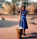
| Introduction - Malawi: | Country | Malawi | | Background | Established in 1891, the British protectorate of Nyasaland became the independent nation of Malawi in 1964. After three decades of one-party rule under President Hastings Kamuzu BANDA the country held multiparty elections in 1994, under a provisional constitution which came into full effect the following year. Current President Bingu wa MUTHARIKA, elected in May 2004 after a failed attempt by the previous president to amend the constitution to permit another term, struggled to assert his authority against his predecessor, culminating in MUTHARIKA quitting the political party on whose ticket he was elected into office. MUTHARIKA subsequently started his own party, the Democratic Progressive Party (DPP), and has continued with a halting anti-corruption campaign against abuses carried out under the previous regime. Increasing corruption, population growth, increasing pressure on agricultural lands, and the spread of HIV/AIDS pose major problems for the country. | |
|
|
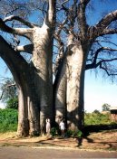
| Location - Malawi: | Location | Southern Africa, east of Zambia | | Geographic coordinates | 13 30 S, 34 00 E | | Map references | Africa | | Area | total: 118,480 sq km
land: 94,080 sq km
water: 24,400 sq km | | Area comparative | slightly smaller than Pennsylvania | | Land boundaries | total: 2,881 km
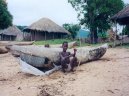
border countries: Mozambique 1,569 km, Tanzania 475 km, Zambia 837 km | | Coastline | 0 km (landlocked) | | Maritime claims | none (landlocked) | | Climate | sub-tropical; rainy season (November to May); dry season (May to November) | | Terrain | narrow elongated plateau with rolling plains, rounded hills, some mountains | | Elevation extremes | lowest point: junction of the Shire River and international boundary with Mozambique 37 m
highest point: Sapitwa (Mount Mlanje) 3,002 m | | Natural resources | limestone, arable land, hydropower, unexploited deposits of uranium, coal, and bauxite | | Land use | arable land: 20.68%
permanent crops: 1.18%
other: 78.14% (2005) | | Irrigated land | 560 sq km (2003) | | Natural hazards | NA | | Environment current issues | deforestation; land degradation; water pollution from agricultural runoff, sewage, industrial wastes; siltation of spawning grounds endangers fish populations | | Environment international agreements | party to: Biodiversity, Climate Change, Climate Change-Kyoto Protocol, Desertification, Endangered Species, Environmental Modification, Hazardous Wastes, Marine Life Conservation, Ozone Layer Protection, Ship Pollution, Wetlands
signed, but not ratified: Law of the Sea | | Geography note | landlocked; Lake Nyasa, some 580 km long, is the countrys most prominent physical feature | |
| People - Malawi: | Population | 13,603,181
note: estimates for this country explicitly take into account the effects of excess mortality due to AIDS; this can result in lower life expectancy, higher infant mortality and death rates, lower population and growth rates, and changes in the distribution of population by age and sex than would otherwise be expected (July 2007 est.) | | Age structure | 0-14 years: 46.1% (male 3,143,724/female 3,130,937)
15-64 years: 51.2% (male 3,491,114/female 3,474,209)
65 years and over: 2.7% (male 155,954/female 207,243) (2007 est.) | | Median age | total: 16.7 years
male: 16.6 years
female: 16.8 years (2007 est.) | | Population growth rate | 2.383% (2007 est.) | | Birth rate | 42.09 births/1,000 population (2007 est.) | | Death rate | 18.25 deaths/1,000 population (2007 est.) | | Net migration rate | 0 migrant(s)/1,000 population (2007 est.) | | Sex ratio | at birth: 1.02 male(s)/female
under 15 years: 1.004 male(s)/female
15-64 years: 1.005 male(s)/female
65 years and over: 0.753 male(s)/female
total population: 0.997 male(s)/female (2007 est.) | | Infant mortality rate | total: 92.1 deaths/1,000 live births
male: 96.27 deaths/1,000 live births
female: 87.85 deaths/1,000 live births (2007 est.) | | Life expectancy at birth | total population: 42.98 years
male: 43.35 years
female: 42.61 years (2007 est.) | | Total fertility rate | 5.74 children born/woman (2007 est.) | | Hiv aids adult prevalence rate | 14.2% (2003 est.) | | Hiv aids people living with hiv aids | 900,000 (2003 est.) | | Hiv aids deaths | 84,000 (2003 est.) | | Nationality | noun: Malawian(s)
adjective: Malawian | | Major infectious diseases | degree of risk: very high
food or waterborne diseases: bacterial and protozoal diarrhea, hepatitis A, and typhoid fever
vectorborne diseases: malaria and plague are high risks in some locations
water contact disease: schistosomiasis (2007) | | Ethnic groups | Chewa, Nyanja, Tumbuka, Yao, Lomwe, Sena, Tonga, Ngoni, Ngonde, Asian, European | | Religions | Christian 79.9%, Muslim 12.8%, other 3%, none 4.3% (1998 census) | | Languages | Chichewa 57.2% (official), Chinyanja 12.8%, Chiyao 10.1%, Chitumbuka 9.5%, Chisena 2.7%, Chilomwe 2.4%, Chitonga 1.7%, other 3.6% (1998 census) | | Literacy | definition: age 15 and over can read and write
total population: 62.7%
male: 76.1%
female: 49.8% (2003 est.) | |
| Government - Malawi: | Country name | conventional long form: Republic of Malawi
conventional short form: Malawi
local long form: Dziko la Malawi
local short form: Malawi
former: British Central African Protectorate, Nyasaland Protectorate, Nyasaland | | Government type | multiparty democracy | | Capital | name: Lilongwe
geographic coordinates: 13 59 S, 33 47 E
time difference: UTC+2 (7 hours ahead of Washington, DC during Standard Time) | | Administrative divisions | 27 districts; Balaka, Blantyre, Chikwawa, Chiradzulu, Chitipa, Dedza, Dowa, Karonga, Kasungu, Likoma, Lilongwe, Machinga (Kasupe), Mangochi, Mchinji, Mulanje, Mwanza, Mzimba, Ntcheu, Nkhata Bay, Nkhotakota, Nsanje, Ntchisi, Phalombe, Rumphi, Salima, Thyolo, Zomba | | Independence | 6 July 1964 (from UK) | | National holiday | Independence Day (Republic Day), 6 July (1964) | | Constitution | 18 May 1994 | | Legal system | based on English common law and customary law; judicial review of legislative acts in the Supreme Court of Appeal; accepts compulsory ICJ jurisdiction with reservations | | Suffrage | 18 years of age; universal | | Executive branch | chief of state: President Bingu wa MUTHARIKA (since 24 May 2004); note - the president is both the chief of state and head of government
head of government: President Bingu wa MUTHARIKA (since 24 May 2004)
cabinet: 46-member Cabinet named by the president
elections: president elected by popular vote for a five-year term (eligible for a second term); election last held 20 May 2004 (next to be held in May 2009)
election results: Bingu wa MUTHARIKA elected president; percent of vote - Bingu wa MUTHARIKA 35.9%, John TEMBO 27.1%, Gwandaguluwe CHAKUAMBA 25.7%, Brown MPINGANJIRA 8.7%, Justin MALEWEZI 2.5% | | Legislative branch | unicameral National Assembly (193 seats; members elected by popular vote to serve five-year terms)
elections: last held 20 May 2004 (next to be held in May 2009)
election results: percent of vote by party - NA; seats by party - UDF 74, MCP 60, independents 24, RP 16, others 18, vacancies 1 | | Judicial branch | Supreme Court of Appeal; High Court (chief justice appointed by the president, puisne judges appointed on the advice of the Judicial Service Commission); magistrates courts | | Political parties and leaders | Alliance for Democracy or AFORD; Congress for National Unity or CONU; Democratic Progressive Party or DPP [Bingu wa MUTHARIKA]; Malawi Congress Party or MCP [John TEMBO]; Malawi Democratic Party or MDP [Kampelo KALUA]; Malawi Forum for Unity and Development or MAFUNDE [George MNESA]; Mgwirizano Coalition or MC [Gwandaguluwe CHAKUAMBA] (coalition of MAFUNDE, MDP, MGODE, NUP, PETRA, PPM, RP); Movement for Genuine Democratic Change or MGODE [Sam Kandodo BANDA]; National Democratic Alliance or NDA [Brown MPINGANJIRA]; National Unity Party or NUP [Harry CHIUME]; Peoples Progressive Movement or PPM [Aleke BANDA]; Peoples Transformation Movement or PETRA [Kamuzu CHIBAMBO]; Republican Party or RP [Gwandaguluwe CHAKUAMBA]; United Democratic Front or UDF | | Political pressure groups and leaders | NA | | International organization participation | ACP, AfDB, AU, C, COMESA, FAO, G-77, IAEA, IBRD, ICAO, ICCt, ICRM, IDA, IFAD, IFC, IFRCS, ILO, IMF, IMO, Interpol, IOC, ISO (correspondent), ITSO, ITU, ITUC, MIGA, MONUC, NAM, ONUB, OPCW, SADC, UN, UNCTAD, UNESCO, UNIDO, UNMIL, UNMIS, UNWTO, UPU, WCL, WCO, WFTU, WHO, WIPO, WMO, WTO | | Diplomatic representation in the us | chief of mission: Ambassador Hawa NDILOWE
chancery: 1156 15th Street, NW, Suite 320, Washington, DC 20005
telephone: [1] (202) 721-0270
FAX: [1] (202) 721-0288 | | Diplomatic representation from the us | chief of mission: Ambassador Alan EASTHAM
embassy: Area 40, Plot 24, Kenyatta Road
mailing address: P. O. Box 30016, Lilongwe 3, Malawi
telephone: [265] (1) 773 166
FAX: [265] (1) 770 471 | | Flag description | three equal horizontal bands of black (top), red, and green with a radiant, rising, red sun centered in the black band | | Government note | no party has a majority in the fractured legislature | |
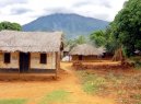
| Economy - Malawi: | Economy overview | Landlocked Malawi ranks among the worlds least developed countries. The economy is predominately agricultural, with about 85% of the population living in rural areas. Agriculture accounts for about one-third of GDP and four-fifths of export revenues. The performance of the tobacco sector is key to short-term growth as tobacco accounts for more than half of exports. The economy depends on substantial inflows of economic assistance from the IMF, the World Bank, and individual donor nations. In 2006, Malawi was approved for relief under the Heavily Indebted Poor Countries (HIPC) program. The government faces many challenges, including developing a market economy, improving educational facilities, facing up to environmental problems, dealing with the rapidly growing problem of HIV/AIDS, and satisfying foreign donors that fiscal discipline is being tightened. In 2005, President MUTHARIKA championed an anticorruption campaign. Since 2005 President MUTHARIKAS government has exhibited improved financial discipline under the guidance of Finance Minister Goodall GONDWE. | | Gdp purchasing power parity | $8.272 billion (2006 est.) | | Gdp official exchange rate | $2.202 billion (2006 est.) | | Gdp real growth rate | 8.5% (2006 est.) | | Gdp per capita ppp | $600 (2006 est.) | | Gdp composition by sector | agriculture: 35.4%
industry: 17.6%
services: 47% (2006 est.) | | Labor force | 4.5 million (2001 est.) | | Labor force by occupation | agriculture: 90%
industry and services: 10% (2003 est.) | | Unemployment rate | NA% | | Population below poverty line | 53% (2004) | | Household income or consumption by percentage share | lowest 10%: NA%
highest 10%: NA% | | Distribution of family income gini index | 50.3 (1997) | | Inflation rate consumer prices | 13.9% (2006) | | Investment gross fixed | 9.2% of GDP (2006 est.) | | Budget | revenues: $818.4 million
expenditures: $895.9 million; including capital expenditures of $NA (2006 est.) | | Public debt | 68.4% of GDP (2006 est.) | | Agriculture products | tobacco, sugarcane, cotton, tea, corn, potatoes, cassava (tapioca), sorghum, pulses, groundnuts, Macadamia nuts; cattle, goats | | Industries | tobacco, tea, sugar, sawmill products, cement, consumer goods | | Industrial production growth rate | 6.4% (2006 est.) | | Electricity production | 1.293 billion kWh (2004) | | Electricity consumption | 1.202 billion kWh (2004) | | Electricity exports | 0 kWh (2004) | | Electricity imports | 0 kWh (2004) | | Oil production | 0 bbl/day (2004 est.) | | Oil consumption | 5,500 bbl/day (2004 est.) | | Oil exports | NA bbl/day | | Oil imports | NA bbl/day | | Oil proved reserves | 0 bbl | | Natural gas production | 0 cu m (2004 est.) | | Natural gas consumption | 0 cu m (2004 est.) | | Current account balance | -$186 million (2006 est.) | | Exports | $513.1 million f.o.b. (2006 est.) | | Exports commodities | tobacco 53%, tea, sugar, cotton, coffee, peanuts, wood products, apparel | | Exports partners | South Africa 12.9%, Germany 9.9%, Egypt 9.8%, US 9.7%, Mozambique 5.5%, Russia 5.5%, Netherlands 4.5% (2006) | | Imports | $767.9 million f.o.b. (2006 est.) | | Imports commodities | food, petroleum products, semimanufactures, consumer goods, transportation equipment | | Imports partners | South Africa 29.3%, Zambia 9.3%, Zimbabwe 7.8%, Mozambique 7.2%, India 6.9%, US 5.4%, Tanzania 5% (2006) | | Reserves of foreign exchange and gold | $175.5 million (2006 est.) | | Debt external | $982.4 million (2006 est.) | | Economic aid recipient | $401.5 million (2001) | | Currency code | Malawian kwacha (MWK) | | Exchange rates | Malawian kwachas per US dollar - 135.96 (2006), 108.894 (2005), 108.898 (2004), 97.433 (2003), 76.687 (2002) | |
| Communications - Malawi: | Fiscal year | 1 July - 30 June | | Telephones main lines in use | 102,700 (2005) | | Telephones mobile cellular | 429,300 (2005) | | Telephone system | general assessment: NA
domestic: system employs open-wire lines, microwave radio relay links, and radiotelephone communications stations
international: country code - 265; satellite earth stations - 2 Intelsat (1 Indian Ocean, 1 Atlantic Ocean) | | Radio broadcast stations | AM 9, FM 5 (plus 15 repeater stations), shortwave 2 (plus one shortwave station on standby) (2001) | | Television broadcast stations | 1 (2001) | | Internet country code | .mw | | Internet hosts | 377 (2006) | | Internet users | 59,700 (2006) | |
| Transportation - Malawi: | Airports | 42 (2006) | | Airports with paved runways | total: 6
over 3,047 m: 1
1,524 to 2,437 m: 1
914 to 1,523 m: 4 (2006) | | Airports with unpaved runways | total: 36
1,524 to 2,437 m: 1
914 to 1,523 m: 15
under 914 m: 20 (2006) | | Railways | total: 797 km
narrow gauge: 797 km 1.067-m gauge (2006) | | Roadways | total: 15,451 km
paved: 6,956 km
unpaved: 8,495 km (2003) | | Waterways | 700 km (on Lake Nyasa (Lake Malawi) and Shire River) (2007) | | Ports and terminals | Chipoka, Monkey Bay, Nkhata Bay, Nkhotakota, Chilumba | |
| Military - Malawi: | Military branches | Malawi Armed Forces: Army (includes Air Wing and Naval Detachment) (2007) | | Military service age and obligation | 18 years of age for voluntary military service; no conscription (2001) | | Manpower available for military service | males age 18-49: 2,430,514 (2005 est.) | | Manpower fit for military service | males age 18-49: 1,226,802 (2005 est.) | | Military expenditures percent of gdp | 1.3% (2006) | |
This page was last updated on 16 September, 2007
Source: CIA >>> |