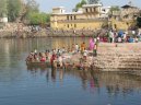
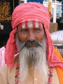
India
India: Travel tips, articles, photos, gallery, cities database, population, pics, flags, statistics, free maps online
Back to Countries, Click to read the whole article: India
| Introduction - India: | Country | India | | Background | The Indus Valley civilization, one of the oldest in the world, dates back at least 5,000 years. Aryan tribes from the northwest infiltrated onto Indian lands about 1500 B.C.; their merger with the earlier Dravidian inhabitants created the classical Indian culture. Arab incursions starting in the 8th century and Turkish in the 12th were followed by those of European traders, beginning in the late 15th century. By the 19th century, Britain had assumed political control of virtually all Indian lands. Indian armed forces in the British army played a vital role in both World Wars. Nonviolent resistance to British colonialism led by Mohandas GANDHI and Jawaharlal NEHRU brought independence in 1947. The subcontinent was divided into the secular state of India and the smaller Muslim state of Pakistan. A third war between the two countries in 1971 resulted in East Pakistan becoming the separate nation of Bangladesh. Despite impressive gains in economic investment and output, India faces pressing problems such as the ongoing dispute with Pakistan over Kashmir, significant overpopulation, environmental degradation, extensive poverty, and ethnic and religious strife. | |
|
|
| Location - India: | Location | Southern Asia, bordering the Arabian Sea and the Bay of Bengal, between Burma and Pakistan | | Geographic coordinates | 20 00 N, 77 00 E | | Map references | Asia | | Area | total: 3,287,590 sq km
land: 2,973,190 sq km
water: 314,400 sq km | | Area comparative | slightly more than one-third the size of the US | | Land boundaries | total: 14,103 km
border countries: Bangladesh 4,053 km, Bhutan 605 km, Burma 1,463 km, China 3,380 km, Nepal 1,690 km, Pakistan 2,912 km | | Coastline | 7,000 km | | Maritime claims | territorial sea: 12 nm
contiguous zone: 24 nm
exclusive economic zone: 200 nm
continental shelf: 200 nm or to the edge of the continental margin | | Climate | varies from tropical monsoon in south to temperate in north | | Terrain | upland plain (Deccan Plateau) in south, flat to rolling plain along the Ganges, deserts in west, Himalayas in north | | Elevation extremes | lowest point: Indian Ocean 0 m
highest point: Kanchenjunga 8,598 m | | Natural resources | coal (fourth-largest reserves in the world), iron ore, manganese, mica, bauxite, titanium ore, chromite, natural gas, diamonds, petroleum, limestone, arable land | | Land use | arable land: 48.83%
permanent crops: 2.8%
other: 48.37% (2005) | | Irrigated land | 558,080 sq km (2003) | | Natural hazards | droughts; flash floods, as well as widespread and destructive flooding from monsoonal rains; severe thunderstorms; earthquakes | | Environment current issues | deforestation; soil erosion; overgrazing; desertification; air pollution from industrial effluents and vehicle emissions; water pollution from raw sewage and runoff of agricultural pesticides; tap water is not potable throughout the country; huge and growing population is overstraining natural resources | | Environment international agreements | party to: Antarctic-Environmental Protocol, Antarctic-Marine Living Resources, Antarctic Treaty, Biodiversity, Climate Change, Climate Change-Kyoto Protocol, Desertification, Endangered Species, Environmental Modification, Hazardous Wastes, Law of the Sea, Ozone Layer Protection, Ship Pollution, Tropical Timber 83, Tropical Timber 94, Wetlands, Whaling
signed, but not ratified: none of the selected agreements | | Geography note | dominates South Asian subcontinent; near important Indian Ocean trade routes; Kanchenjunga, third tallest mountain in the world, lies on the border with Nepal | |
| People - India: | Population | 1,129,866,154 (July 2007 est.) | | Age structure | 0-14 years: 31.8% (male 188,208,196/female 171,356,024)
15-64 years: 63.1% (male 366,977,821/female 346,034,565)
65 years and over: 5.1% (male 27,258,259/female 30,031,289) (2007 est.) | | Median age | total: 24.8 years
male: 24.5 years
female: 25.2 years (2007 est.) | | Population growth rate | 1.606% (2007 est.) | | Birth rate | 22.69 births/1,000 population (2007 est.) | | Death rate | 6.58 deaths/1,000 population (2007 est.) | | Net migration rate | -0.05 migrant(s)/1,000 population (2007 est.) | | Sex ratio | at birth: 1.12 male(s)/female
under 15 years: 1.098 male(s)/female
15-64 years: 1.061 male(s)/female
65 years and over: 0.908 male(s)/female
total population: 1.064 male(s)/female (2007 est.) | | Infant mortality rate | total: 34.61 deaths/1,000 live births
male: 39.42 deaths/1,000 live births
female: 29.23 deaths/1,000 live births (2007 est.) | | Life expectancy at birth | total population: 68.59 years
male: 66.28 years
female: 71.17 years (2007 est.) | | Total fertility rate | 2.81 children born/woman (2007 est.) | | Hiv aids adult prevalence rate | 0.9% (2001 est.) | | Hiv aids people living with hiv aids | 5.1 million (2001 est.) | | Hiv aids deaths | 310,000 (2001 est.) | | Nationality | noun: Indian(s)
adjective: Indian | | Major infectious diseases | degree of risk: high
food or waterborne diseases: bacterial diarrhea, hepatitis A and E, and typhoid fever
vectorborne diseases: dengue fever, malaria, and Japanese encephalitis are high risks in some locations
animal contact disease: rabies
note: highly pathogenic H5N1 avian influenza has been identified among birds in this country or surrounding region; it poses a negligible risk with extremely rare cases possible among US citizens who have close contact with birds (2007) | | Ethnic groups | Indo-Aryan 72%, Dravidian 25%, Mongoloid and other 3% (2000) | | Religions | Hindu 80.5%, Muslim 13.4%, Christian 2.3%, Sikh 1.9%, other 1.8%, unspecified 0.1% (2001 census) | | Languages | English enjoys associate status but is the most important language for national, political, and commercial communication; Hindi is the national language and primary tongue of 30% of the people; there are 14 other official languages: Bengali, Telugu, Marathi, Tamil, Urdu, Gujarati, Malayalam, Kannada, Oriya, Punjabi, Assamese, Kashmiri, Sindhi, and Sanskrit; Hindustani is a popular variant of Hindi/Urdu spoken widely throughout northern India but is not an official language | | Literacy | definition: age 15 and over can read and write
total population: 61%
male: 73.4%
female: 47.8% (2001 census) | |
| Government - India: | Country name | conventional long form: Republic of India
conventional short form: India
local long form: Republic of India/Bharatiya Ganarajya
local short form: India/Bharat | | Government type | federal republic | | Capital | name: New Delhi
geographic coordinates: 28 36 N, 77 12 E
time difference: UTC+5.5 (10.5 hours ahead of Washington, DC during Standard Time) | | Administrative divisions | 28 states and 7 union territories*; Andaman and Nicobar Islands*, Andhra Pradesh, Arunachal Pradesh, Assam, Bihar, Chandigarh*, Chhattisgarh, Dadra and Nagar Haveli*, Daman and Diu*, Delhi*, Goa, Gujarat, Haryana, Himachal Pradesh, Jammu and Kashmir, Jharkhand, Karnataka, Kerala, Lakshadweep*, Madhya Pradesh, Maharashtra, Manipur, Meghalaya, Mizoram, Nagaland, Orissa, Puducherry*, Punjab, Rajasthan, Sikkim, Tamil Nadu, Tripura, Uttar Pradesh, Uttarakhand, West Bengal | | Independence | 15 August 1947 (from UK) | | National holiday | Republic Day, 26 January (1950) | | Constitution | 26 January 1950; amended many times | | Legal system | based on English common law; judicial review of legislative acts; accepts compulsory ICJ jurisdiction with reservations; separate personal law codes apply to Muslims, Christians, and Hindus | | Suffrage | 18 years of age; universal | | Executive branch | chief of state: President Pratibha PATIL (since 25 July 2007); Vice President Hamid ANSARI (since 11 August 2007)
head of government: Prime Minister Manmohan SINGH (since 22 May 2004)
cabinet: Cabinet appointed by the president on the recommendation of the prime minister
elections: president elected by an electoral college consisting of elected members of both houses of Parliament and the legislatures of the states for a five-year term (no term limits); election last held 21 July 2007 (next to be held in July 2012); vice president elected by both houses of Parliament for a five-year term; election last held 12 August 2002 (next to be held August 2007); prime minister chosen by parliamentary members of the majority party following legislative elections; election last held April - May 2004 (next to be held May 2009)
election results: Pratibha PATIL elected president; percent of vote - 65.8%; Bhairon Singh SHEKHAWAT - 34.2% | | Legislative branch | bicameral Parliament or Sansad consists of the Council of States or Rajya Sabha (a body consisting of not more than 250 members up to 12 of whom are appointed by the president, the remainder are chosen by the elected members of the state and territorial assemblies; members serve six-year terms) and the Peoples Assembly or Lok Sabha (545 seats; 543 elected by popular vote, 2 appointed by the president; members serve five-year terms)
elections: Peoples Assembly - last held 20 April through 10 May 2004 (next must be held before May 2009)
election results: Peoples Assembly - percent of vote by party - NA; seats by party - INC 147, BJP 129, CPI (M) 43, SP 38, RJD 23, DMK 16, BSP 15, SS 12, BJD 11, CPI 10, NCP 10, JD (U) 8, SAD 8, PMK 6, JMM 5, LJSP 4, MDMK 4, TDP 4, TRS 4, independent 6, other 29, vacant 13; note - seats by party as of December 2006 | | Judicial branch | Supreme Court (one chief justice and 25 associate justices are appointed by the president and remain in office until they reach the age of 65 or are removed for proved misbehavior) | | Political parties and leaders | Bahujan Samaj Party or BSP [MAYAWATI]; Bharatiya Janata Party or BJP [Rajnath SINGH]; Biju Janata Dal or BJD [Naveen PATNAIK]; Communist Party of India or CPI [Ardhendu Bhushan BARDHAN]; Communist Party of India-Marxist or CPI-M [Prakash KARAT]; Dravida Munnetra Kazagham or DMK [M. KARUNANIDHI]; Indian National Congress or INC [Sonia GANDHI]; Janata Dal (United) or JD(U) [Sharad YADEV]; Jharkhand Mukti Morcha or JMM [Shibu SOREN]; Lok Jan Shakti Party or LJSP [Ram Vilas PASWAN]; Marumalarchi Dravida Munnetra Kazhagam or MDMK [VAIKU]; Nationalist Congress Party or NCP [Sharad PAWAR]; Pattali Makkal Katchi or PMK [S. RAMADOSS]; Rashtriya Janata Dal or RJD [Laloo Prasad YADAV]; Samajwadi Party or SP [Mulayam Singh YADAV]; Shiromani Akali Dal or SAD [Prakash Singh BADAL]; Shiv Sena or SS [Bal THACKERAY]; Telangana Rashtra Samithi or TRS [K. Chandrasekhar RAO]; Telugu Desam Party or TDP [Chandrababu NAIDU]; note - India has dozens of national and regional political parties; only parties with four or more seats in the Peoples Assembly are listed | | Political pressure groups and leaders | numerous religious or militant/chauvinistic organizations, including Vishwa Hindu Parishad, Bajrang Dal, and Rashtriya Swayamsevak Sangh; various separatist groups seeking greater communal and/or regional autonomy, including the All Parties Hurriyat Conference in the Kashmir Valley and the National Socialist Council of Nagaland in the Northeast | | International organization participation | AfDB, ARF, AsDB, ASEAN (dialogue partner), BIMSTEC, BIS, C, CERN (observer), CP, EAS, FAO, G- 6, G-15, G-24, G-77, IAEA, IBRD, ICAO, ICC, ICRM, IDA, IFAD, IFC, IFRCS, IHO, ILO, IMF, IMO, IMSO, Interpol, IOC, IOM (observer), IPU, ISO, ITSO, ITU, ITUC, MIGA, MONUC, NAM, OAS (observer), ONUB, OPCW, PCA, PIF (partner), SAARC, SACEP, SCO (observer), UN, UNCTAD, UNDOF, UNESCO, UNHCR, UNIDO, UNIFIL, UNMEE, UNMIS, UNMOVIC, UNOCI, UNOMIG, UNWTO, UPU, WCL, WCO, WFTU, WHO, WIPO, WMO, WTO | | Diplomatic representation in the us | chief of mission: Ambassador Ranendra SEN
chancery: 2107 Massachusetts Avenue NW, Washington, DC 20008; note - Consular Wing located at 2536 Massachusetts Avenue NW, Washington, DC 20008
telephone: [1] (202) 939-7000
FAX: [1] (202) 265-4351
consulate(s) general: Chicago, Houston, New York, San Francisco | | Diplomatic representation from the us | chief of mission: Ambassador David C. MULFORD
embassy: Shantipath, Chanakyapuri, New Delhi 110021
mailing address: use embassy street address
telephone: [91] (11) 2419-8000
FAX: [91] (11) 2419-0017
consulate(s) general: Chennai (Madras), Kolkata (Calcutta), Mumbai (Bombay) | | Flag description | three equal horizontal bands of saffron (subdued orange) (top), white, and green with a blue chakra (24-spoked wheel) centered in the white band; similar to the flag of Niger, which has a small orange disk centered in the white band | |
| Economy - India: | Economy overview | Indias diverse economy encompasses traditional village farming, modern agriculture, handicrafts, a wide range of modern industries, and a multitude of services. Services are the major source of economic growth, accounting for more than half of Indias output with less than one third of its labor force. About three-fifths of the work force is in agriculture, leading the UPA government to articulate an economic reform program that includes developing basic infrastructure to improve the lives of the rural poor and boost economic performance. The government has reduced controls on foreign trade and investment. Tariffs averaged 12.5% on non-agricultural items in 2006. Higher limits on foreign direct investment were permitted in a few key sectors, such as telecommunications. However, tariff spikes in sensitive categories, including agriculture, and incremental progress on economic reforms still hinder foreign access to Indias vast and growing market. Privatization of government-owned industries remained stalled in 2006, and continues to generate political debate; populist pressure from within the UPA government and from its Left Front allies continues to restrain needed initiatives. The economy has posted an average growth rate of more than 7% in the decade since 1996, reducing poverty by about 10 percentage points. India achieved 8.5% GDP growth in 2006, significantly expanding manufacturing. India is capitalizing on its large numbers of well-educated people skilled in the English language to become a major exporter of software services and software workers. Economic expansion has helped New Delhi continue to make progress in reducing its federal fiscal deficit. However, strong growth - more than 8 percent growth in each of the last three years - combined with easy consumer credit and a real estate boom is fueling inflation concerns. The huge and growing population is the fundamental social, economic, and environmental problem. | | Gdp purchasing power parity | $4.156 trillion (2006 est.) | | Gdp official exchange rate | $804 billion (2006 est.) | | Gdp real growth rate | 9.2% (2006 est.) | | Gdp per capita ppp | $3,800 (2006 est.) | | Gdp composition by sector | agriculture: 19.9%
industry: 19.3%
services: 60.7% (2005 est.) | | Labor force | 509.3 million (2006 est.) | | Labor force by occupation | agriculture: 60%
industry: 12%
services: 28% (2003) | | Unemployment rate | 7.8% (2006 est.) | | Population below poverty line | 25% (2002 est.) | | Household income or consumption by percentage share | lowest 10%: 3.5%
highest 10%: 33.5% (1997) | | Distribution of family income gini index | 32.5 (2000) | | Inflation rate consumer prices | 5.3% (2006 est.) | | Investment gross fixed | 29.2% of GDP (2006 est.) | | Budget | revenues: $109.4 billion
expenditures: $143.8 billion; including capital expenditures of $15 billion (2006 est.) | | Public debt | 52.8% of GDP (federal and state debt combined) (2006 est.) | | Agriculture products | rice, wheat, oilseed, cotton, jute, tea, sugarcane, potatoes; cattle, water buffalo, sheep, goats, poultry; fish | | Industries | textiles, chemicals, food processing, steel, transportation equipment, cement, mining, petroleum, machinery, software | | Industrial production growth rate | 7.5% (2006 est.) | | Electricity production | 630.6 billion kWh (2004) | | Electricity consumption | 587.9 billion kWh (2004) | | Electricity exports | 60 million kWh (2004) | | Electricity imports | 1.5 billion kWh (2004) | | Oil production | 785,000 bbl/day (2005 est.) | | Oil consumption | 2.45 million bbl/day (2004 est.) | | Oil exports | 350,000 bbl/day (2005 est.) | | Oil imports | 2.098 million bbl/day (2004 est.) | | Oil proved reserves | 5.371 billion bbl (1 January 2005 est.) | | Natural gas production | 28.2 billion cu m (2004 est.) | | Natural gas consumption | 30.83 billion cu m (2004 est.) | | Natural gas exports | 0 cu m (2004 est.) | | Natural gas imports | 2.63 billion cu m (2004 est.) | | Natural gas proved reserves | 853.5 billion cu m (1 January 2005 est.) | | Current account balance | -$26.4 billion (2006 est.) | | Exports | $112 billion f.o.b. (2006 est.) | | Exports commodities | textile goods, gems and jewelry, engineering goods, chemicals, leather manufactures | | Exports partners | US 17.4%, UAE 8.5%, China 7.9%, UK 4.4% (2006) | | Imports | $187.9 billion f.o.b. (2006 est.) | | Imports commodities | crude oil, machinery, gems, fertilizer, chemicals | | Imports partners | China 8.5%, US 5.9%, Germany 4.5%, Singapore 4.5% (2006) | | Reserves of foreign exchange and gold | $165 billion (2006 est.) | | Debt external | $132.1 billion (30 June 2006 est.) | | Economic aid recipient | $2.9 billion (FY98/99) | | Currency code | Indian rupee (INR) | | Exchange rates | Indian rupees per US dollar - 45.3 (2006), 44.101 (2005), 45.317 (2004), 46.583 (2003), 48.61 (2002) | |
| Communications - India: | Fiscal year | 1 April - 31 March | | Telephones main lines in use | 49.75 million (2005) | | Telephones mobile cellular | 166.1 million (2006) | | Telephone system | general assessment: recent deregulation and liberalization of telecommunications laws and policies have prompted rapid growth; local and long distance service provided throughout all regions of the country, with services primarily concentrated in the urban areas; steady improvement is taking place with the recent admission of private and private-public investors, but telephone density remains low at about 10 for each 100 persons nationwide and only 1 per 100 persons in rural areas; there remains a national waiting list of over 1.7 million; fastest growth is in cellular service with modest growth in fixed lines
domestic: expansion of domestic service, although still weak in rural areas, resulted from increased competition and dramatic reductions in price led in large part by wireless service; mobile cellular service (both CDMA and GSM) introduced in 1994 and organized nationwide into four metropolitan cities and 19 telecom circles each with about three private service providers and one state-owned service provider; in recent years significant trunk capacity added in the form of fiber-optic cable and one of the worlds largest domestic satellite systems, the Indian National Satellite system (INSAT), with 6 satellites supporting 33,000 very small aperture terminals (VSAT)
international: country code - 91; satellite earth stations - 8 Intelsat (Indian Ocean) and 1 Inmarsat (Indian Ocean region); 9 gateway exchanges operating from Mumbai (Bombay), New Delhi, Kolkata (Calcutta), Chennai (Madras), Jalandhar, Kanpur, Gandhinagar, Hyderabad, and Ernakulam; 6 submarine cables, including Sea-Me-We-3 with landing sites at Cochin and Mumbai (Bombay), Sea-Me-We-4 with landing site at Chennai, Fiber-Optic Link Around the Globe (FLAG) with landing site at Mumbai (Bombay), South Africa - Far East (SAFE) with landing site at Cochin, i2icn linking to Singapore with landing sites at Mumbai (Bombay) and Chennai (Madras), and Tata Indicom linking Singapore and Chennai (Madras), provide a significant increase in the bandwidth available for both voice and data traffic (2006) | | Radio broadcast stations | AM 153, FM 91, shortwave 68 (1998) | | Television broadcast stations | 562 (1997) | | Internet country code | .in | | Internet hosts | 1.543 million (2006) | | Internet users | 60 million (2005) | |
| Transportation - India: | Airports | 341 (2006) | | Airports with paved runways | total: 243
over 3,047 m: 17
2,438 to 3,047 m: 51
1,524 to 2,437 m: 73
914 to 1,523 m: 81
under 914 m: 21 (2006) | | Airports with unpaved runways | total: 98
2,438 to 3,047 m: 1
1,524 to 2,437 m: 7
914 to 1,523 m: 42
under 914 m: 48 (2006) | | Heliports | 28 (2006) | | Pipelines | condensate/gas 8 km; gas 5,184 km; liquid petroleum gas 1,993 km; oil 6,500 km; refined products 6,152 km (2006) | | Railways | total: 63,221 km
broad gauge: 46,807 km 1.676-m gauge (17,343 km electrified)
narrow gauge: 13,290 km 1.000-m gauge (165 km electrified); 3,124 km 0.762-m gauge and 0.610-m gauge (2006) | | Roadways | total: 3,383,344 km
paved: 1,603,705 km
unpaved: 1,779,639 km (2002) | | Waterways | 14,500 km
note: 5,200 km on major rivers and 485 km on canals suitable for mechanized vessels (2006) | | Merchant marine | total: 316 ships (1000 GRT or over) 7,772,313 GRT/13,310,858 DWT
by type: bulk carrier 96, cargo 72, chemical tanker 13, container 8, liquefied gas 17, passenger 3, passenger/cargo 10, petroleum tanker 96, roll on/roll off 1
foreign-owned: 10 (China 2, Hong Kong 1, UAE 6, UK 1)
registered in other countries: 46 (Bahamas 1, Comoros 1, Cyprus 5, North Korea 1, Liberia 3, Malta 1, Mauritius 2, Panama 19, Saint Vincent and the Grenadines 6, Singapore 5, Venezuela 1, unknown 1) (2006) | | Ports and terminals | Chennai, Haldia, Jawaharal Nehru, Kandla, Kolkata (Calcutta), Mumbai (Bombay), New Mangalore, Vishakhapatnam | |
| Military - India: | Military branches | Army, Navy (includes naval air arm), Air Force, Coast Guard, various security or paramilitary forces (includes Border Security Force, Assam Rifles, National Security Guards, Indo-Tibetan Border Police, Special Frontier Force, Central Reserve Police Force, Central Industrial Security Force, Railway Protection Force, and Defense Security Corps) | | Military service age and obligation | 16 years of age for voluntary military service (2001) | | Manpower available for military service | males age 16-49: 287,551,111
females age 16-49: 268,524,835 (2005 est.) | | Manpower fit for military service | males age 16-49: 219,471,999
females age 16-49: 209,917,553 (2005 est.) | | Manpower reaching military service age annually | males age 18-49: 11,446,452
females age 16-49: 10,665,877 (2005 est.) | | Refugees and internally displaced persons | refugees (country of origin): 77,200 (Tibet/China), 50,730 (Sri Lanka), 9,700 (Afghanistan)
IDPs: at least 600,000 (about half are Kashmiri Pandits from Jammu and Kashmir) (2006) | | Military expenditures percent of gdp | 2.5% (2006) | | Trafficking in persons | current situation: India is a source, destination, and transit country for men, women, and children trafficked for the purposes of forced or bonded labor and commercial sexual exploitation; the large population of men, women, and children - numbering in the millions - in debt bondage face involuntary servitude in brick kilns, rice mills, and embroidery factories, while some children endure involuntary servitude as domestic servants; internal trafficking of women and girls for the purposes of commercial sexual exploitation and forced marriage also occurs; the government estimates that 90 percent of Indias sex trafficking is internal; India is also a destination for women and girls from Nepal and Bangladesh trafficked for the purpose of commercial sexual exploitation; boys from Afghanistan, Pakistan, and Bangladesh are trafficked through India to the Gulf states for involuntary servitude as child camel jockeys; Indian men and women migrate willingly to the Persian Gulf region for work as domestic servants and low-skilled laborers, but some later find themselves in situations of involuntary servitude including extended working hours, nonpayment of wages, restrictions on their movement by withholding of their passports or confinement to the home, and physical or sexual abuse
tier rating: Tier 2 Watch List - India has been on the Tier 2 Watch List since 2004 for its failure to show evidence of increasing efforts to address trafficking in persons | | Disputes international | since China and India launched a security and foreign policy dialogue in 2005, consolidated discussions related to the dispute over most of their rugged, militarized boundary, regional nuclear proliferation, Indian claims that China transferred missiles to Pakistan, and other matters continue; various talks and confidence-building measures have cautiously begun to defuse tensions over Kashmir, particularly since the October 2005 earthquake in the region; Kashmir nevertheless remains the site of the worlds largest and most militarized territorial dispute with portions under the de facto administration of China (Aksai Chin), India (Jammu and Kashmir), and Pakistan (Azad Kashmir and Northern Areas); India and Pakistan have maintained the 2004 cease fire in Kashmir and initiated discussions on defusing the armed stand-off in the Siachen glacier region; Pakistan protests Indias fencing the highly militarized Line of Control and construction of the Baglihar Dam on the Chenab River in Jammu and Kashmir, which is part of the larger dispute on water sharing of the Indus River and its tributaries; UN Military Observer Group in India and Pakistan (UNMOGIP) has maintained a small group of peacekeepers since 1949; India does not recognize Pakistans ceding historic Kashmir lands to China in 1964; to defuse tensions and prepare for discussions on a maritime boundary, India and Pakistan seek technical resolution of the disputed boundary in Sir Creek estuary at the mouth of the Rann of Kutch in the Arabian Sea; Pakistani maps continue to show its Junagadh claim in Indian Gujarat State; discussions with Bangladesh remain stalled to delimit a small section of river boundary, to exchange territory for 51 Bangladeshi exclaves in India and 111 Indian exclaves in Bangladesh, to allocate divided villages, and to stop illegal cross-border trade, migration, violence, and transit of terrorists through the porous border; Bangladesh protests Indias attempts to fence off high-traffic sections of the border; dispute with Bangladesh over New Moore/South Talpatty/Purbasha Island in the Bay of Bengal deters maritime boundary delimitation; India seeks cooperation from Bhutan and Burma to keep Indian Nagaland and Assam separatists from hiding in remote areas along the borders; Joint Border Committee with Nepal continues to examine contested boundary sections, including the 400 square kilometer dispute over the source of the Kalapani River; India maintains a strict border regime to keep out Maoist insurgents and control illegal cross-border activities from Nepal | |
This page was last updated on 16 September, 2007
Source: CIA >>> |