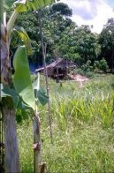
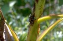
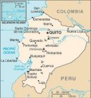
Města státu: Ekvádor (cestopis) ,region: Orellana
| Název | Obyvatele | Nad. výška | Souřadnice |
Ancayacu |
| 236 m | 0°42' S; 76°0' W |
Armenia |
| 300 m | 0°31' S; 77°4' W |
Armenia Vieja |
| 300 m | 0°31' S; 77°4' W |
Arrozal |
| 186 m | 0°46' S; 75°16' W |
Avila (Vila) |
| 645 m | 0°37' S; 77°25' W |
Bellavista |
| 202 m | 0°45' S; 75°34' W |
Bello Horinzonte |
| 196 m | 0°54' S; 75°25' W |
Bello Horizonte |
| 196 m | 0°54' S; 75°25' W |
Bello Orizonte |
| 196 m | 0°54' S; 75°25' W |
Biffarini |
| 185 m | 0°52' S; 75°13' W |
Boca Suno |
| 302 m | 0°43' S; 77°7' W |
Boca Tiputini |
| 200 m | 0°48' S; 75°32' W |
Boca Yanayacu |
| 189 m | 0°52' S; 75°13' W |
Cacao Punta |
| 302 m | 0°39' S; 77°7' W |
Cacao Punto |
| 302 m | 0°39' S; 77°7' W |
Capihuara |
| 315 m | 0°28' S; 77°13' W |
Capihuara Playa |
| 315 m | 0°28' S; 77°13' W |
Capitan Augosto Rivadeneira (Capitán Augosto Rivadeneira) |
| 223 m | 0°37' S; 75°52' W |
Capitan Rivadeneira (Capitán Rivadeneira) |
| 223 m | 0°37' S; 75°52' W |
Caserio (Caserío) |
| 242 m | 0°48' S; 76°15' W |
Ciudad De Avila |
| 645 m | 0°37' S; 77°25' W |
Coca |
| 299 m | 0°28' S; 76°58' W |
Concepcion (Concepción) |
| 464 m | 0°48' S; 77°25' W |
Cotacocha |
| 254 m | 0°45' S; 75°32' W |
Cotapino |
| 637 m | 0°42' S; 77°28' W |
Coto Chicta |
| 227 m | 0°43' S; 75°34' W |
Cotococha |
| 254 m | 0°45' S; 75°32' W |
Davalos (Dávalos) |
| 196 m | 0°52' S; 75°24' W |
Delta |
| 222 m | 0°34' S; 75°50' W |
Delta Izurrieta |
| 222 m | 0°34' S; 75°50' W |
Derna |
| 280 m | 0°27' S; 76°43' W |
Descanso |
| 284 m | 0°25' S; 76°46' W |
Destino |
| 198 m | 0°51' S; 75°28' W |
Eden (Edén) |
| 236 m | 0°28' S; 76°2' W |
El Destino |
| 198 m | 0°51' S; 75°28' W |
El Eden (El Edén) |
| 236 m | 0°28' S; 76°2' W |
Eloy Alfaro |
| 198 m | 0°51' S; 75°25' W |
El Placer |
| 185 m | 0°55' S; 75°13' W |
El Porvenir |
| 255 m | 0°30' S; 76°24' W |
El Progreso |
| 192 m | 0°49' S; 75°15' W |
El Retiro |
| 250 m | 0°28' S; 76°17' W |
Elva |
| 200 m | 0°49' S; 75°28' W |
Estrella Yacu |
| 300 m | 0°25' S; 77°7' W |
Felix (Félix) |
| 194 m | 0°55' S; 75°24' W |
Fenix (Fénix) |
| 196 m | 0°54' S; 75°25' W |
Florencia |
| 197 m | 0°52' S; 75°27' W |
Francisco De Orellana |
| 299 m | 0°28' S; 76°58' W |
Germania |
| 194 m | 0°55' S; 75°24' W |
Gonzalo Pizarro |
| 897 m | 0°33' S; 77°25' W |
Himalaya |
| 229 m | 0°34' S; 75°58' W |
Huino |
| 302 m | 0°37' S; 77°7' W |
Huiririma |
| 206 m | 0°43' S; 75°37' W |
La Coca |
| 299 m | 0°28' S; 76°58' W |
La Joya De Los Sachas |
| 295 m | 0°19' S; 76°50' W |
La Victoria |
| 236 m | 0°46' S; 75°31' W |
Londono (Londo?o) |
| 184 m | 0°57' S; 75°13' W |
Loreto |
| 452 m | 0°40' S; 77°19' W |
Merced |
| 205 m | 0°48' S; 75°31' W |
Metija |
| 195 m | 0°54' S; 75°20' W |
Mihuanoyacu |
| 205 m | 1°16' S; 76°9' W |
Nueva Armenia |
| 197 m | 0°52' S; 75°28' W |
Nuevo Rocafuerte |
| 194 m | 0°55' S; 75°24' W |
Paushiyacu |
| 292 m | 1°22' S; 76°55' W |
Payamino |
| 304 m | 0°30' S; 77°16' W |
Placer |
| 184 m | 0°55' S; 75°13' W |
Pompeya |
| 271 m | 0°25' S; 76°37' W |
Porvenir |
| 255 m | 0°30' S; 76°24' W |
Primavera |
| 279 m | 0°25' S; 76°43' W |
Progreso |
| 225 m | 0°34' S; 75°54' W |
Puerto Alfaro |
| 200 m | 0°49' S; 75°28' W |
Puerto Francisco De Orellana |
| 299 m | 0°28' S; 76°58' W |
Puerto Loja |
| 185 m | 0°55' S; 75°13' W |
Puerto Miranda |
| 199 m | 0°51' S; 75°31' W |
Puerto Ventura |
| 196 m | 1°1' S; 75°28' W |
Quiroz |
| 304 m | 0°16' S; 77°10' W |
Reparado |
| 223 m | 1°16' S; 76°24' W |
Rocafuerte |
| 194 m | 0°55' S; 75°24' W |
San Antonio |
| 194 m | 0°55' S; 75°19' W |
San Francisco |
| 254 m | 0°30' S; 76°22' W |
San Jose De Mote (San José De Mote) |
| 536 m | 0°25' S; 77°19' W |
San Jose De Payamino (San José De Payamino) |
| 304 m | 0°30' S; 77°16' W |
San Jose De Suno (San José De Suno) |
| 803 m | 0°31' S; 77°25' W |
San Jose Nuevo (San José Nuevo) |
| 536 m | 0°25' S; 77°19' W |
San Jose Viejo (San José Viejo) |
| 803 m | 0°31' S; 77°25' W |
San Luis |
| 193 m | 0°55' S; 75°19' W |
San Miguel |
| 305 m | 0°12' S; 77°4' W |
San Pedro De Aguarico |
|
| 0°55' S; 75°24' W |
San Roque |
| 245 m | 0°25' S; 76°12' W |
San Sebastian Del Coca (San Sebastián Del Coca) |
| 300 m | 0°19' S; 77°0' W |
Santa Maria De Huiririma (Santa María De Huiririma) |
| 206 m | 0°43' S; 75°37' W |
Santa Rosa |
| 203 m | 0°49' S; 75°30' W |
Sardinas |
| 441 m | 0°6' S; 77°7' W |
Sinchi Chicta |
| 212 m | 0°39' S; 75°40' W |
Suno | 20 313 | 302 m | 0°43' S; 77°7' W |
Tiputini |
| 245 m | 0°45' S; 75°31' W |
Yana-yacu |
| 189 m | 0°52' S; 75°13' W |
Yasuni (Yasuní) |
| 194 m | 0°55' S; 75°24' W |
Yuturi |
| 230 m | 0°33' S; 76°0' W |
Zancudo |
| 211 m | 0°33' S; 75°30' W |
Krok zpět, Ukázat kontinenty ... |
Free IQ test online
An Intelligence Quotient or IQ is a score derived from one of several different standardized tests attempting to measure intelligence. Although the term "IQ" is still in common use, the scoring of modern IQ tests such as the Wechsler Adult Intelligence Scale is now based on a projection of the subject's measured rank on the Gaussian bell curve with a center value (average IQ) of 100, and a standard deviation of 15, although different tests may have different standard deviations. The average IQ scores for many populations have been rising at an average rate of three points per decade since the early 20th century with most of the increase in the lower half of the IQ range: a phenomenon called the Flynn effect. It is disputed whether these changes in scores reflect real changes in intellectual abilities, or merely methodological problems with past or present testing. (Wikipedie)
IQ test lasts approximately 30 minutes and contains 40 questions !
In the IQ test you must focus on the maximum. Test questions are simple. In the IQ test may not use the calculator and paper.
Free IQ test online :
Banner on your page · Visitor's book · Besplatnye igry onlajn · Free games online · CZ Hry · RoboStav
Copyright (c) 2026 by TiptopGlobe.com. All Rights Reserved!